|
| |
| |
|
|
SINCE its emergence as a science, archaeology has wrestled with a paradox: discovery involves destruction, and investigation requires intrusion. An archaeological dig cannot be undone. Once a layer has been stripped away, any information not recorded is lost. Most archaeologists have had the experience of trying to discover something new about a site that has been completely excavated, only to find that the question they wanted to ask had not occurred to the original diggers.
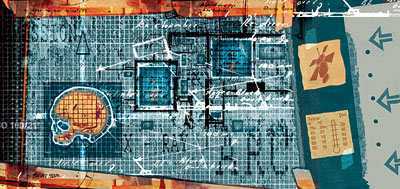
So knowing what lies beneath the surface before the trowel hits the soil has long been the dream of many an archaeologist. As well as saving time in determining where to dig, it would enable archaeologists to answer questions with a minimum of destruction—and potentially none at all. This dream is slowly becoming a reality, as a result of improvements in non-destructive surveying techniques. Archaeology has never been a wealthy discipline, but by borrowing tools developed for more well-endowed professions, archaeologists are developing X-ray vision—or, to be precise, infra-red, microwave and magnetic vision, which are even better.
Such tools enable archaeologists to identify and target small areas of interest, and to move away from the complete excavation of sites towards a more selective approach. This method, known as the “conservation model” of archaeology, means that archaeological resources are maintained for future generations, who will be armed both with novel technologies and new questions. As sensing techniques improve, archaeologists are also benefiting from the tumbling price of computing power, which enables them to combine, overlay and analyse data from multiple sources, yielding further insights.
To demonstrate the potential of such techniques, a group of archaeologists from the University of Arkansas, led by Fredrick Limp and Kenneth Kvamme, have been investigating the site of Army City in Kansas. Established in 1917, it was a bustling town, complete with hotels and theatres. In 1921 it burned to the ground, leaving no trace of its former existence. Or so it appeared. But last year, when the archaeologists began to map what is now an empty hayfield, they found that they could see the precise locations of roads, pavements and rooms of buildings. They could even trace the sewage system. “It was almost as though the soil was transparent,” says Dr Limp.
The team combined several techniques. A ground-based magnetic gradiometry survey, which measures variations in the magnetic properties of the soil, detected buried sewage pipes containing iron. Variations in the magnetic polarity even revealed joins where one pipe met another. An electrical resistivity survey, which works by passing an electric current through the ground, detected buried pavements and bricks, which are more resistant to electricity than the surrounding soil. These observations, and the results of other ground-based surveys, were combined with traditional aerial photography.
The next step, says Dr Limp, is to make use of satellite photography too. At the moment, he says, the resolution of publicly available Earth-observation satellites, such as Landsat-7, is often too poor to provide the necessary detail of an excavation site. But he thinks that new commercial satellites will provide sufficient magnification. His team is still processing data acquired from one such satellite, QuickBird, of the Army City site in July. It can see objects as small as half a metre across.
The use of commercial satellites is still beyond the budgets of many archaeologists. But their potential is significant. Dr Limp suggests that they could liberate archaeology from its current focus on areas of a few square metres and allow sites spread over many hectares to be analysed in detail. Payson Sheets and his colleagues at the University of Colorado, for example, have started to use data from another commercial satellite, Ikonos, to map ancient footpaths in Arenal, Costa Rica. By studying the patterns in their layout, the researchers hope to make connections between cemeteries and villages, which may provide clues about the former inhabitants' behaviour.
Another technology that archaeologists are taking to is thermal imaging. This employs high-resolution cameras that are sensitive to the so-called near infra-red. This part of the infra-red spectrum, with wavelengths close to that of visible light, carries heat energy. Thermal imaging thus records slight differences in temperature. Such differences at the surface are often tell-tales of what lies beneath. A stone foundation, for instance, retains heat differently from a pit that holds moisture.
One such camera, used by Dr Kvamme and his colleagues, can monitor temperature differences as small as 0.1°C. In August, Dr Kvamme tested this camera at Double Ditch, a prehistoric fortified settlement along the Missouri River in North Dakota. Initial results, though not fully analysed, have turned out to be “shockingly good”, according to Dr Kvamme. The researchers were able to see the boundaries of houses previously unknown to them, and were even able to make out the doorways of these dwellings. Two of the site's four fortification ditches were also better defined by the thermal data. Because of these discoveries, the researchers have realised that the settlement was far larger than originally believed. Indeed, according to Dr Kvamme, it should really have been named “Quadruple Ditch”.
Dr Kvamme's technique is passive, since it relies on what nature provides in the way of heat. Dan Blumberg of the Ben-Gurion University of the Negev, in Beer Sheva, Israel, has a more forceful approach. He pumps the ground full of microwaves, to see what gets reflected back. Man-made objects buried under shifting sands, such as pipes or water aqueducts, are particularly good at reflecting microwaves. Indeed, in one of the early successes of remote archaeology, Ronald Blom and his colleagues at NASA's Jet Propulsion Laboratory, in Pasadena, California, used short-wavelength microwaves in 1992 to reveal caravan trails leading to the lost city of Ubar in the Arabian peninsula.
The signs of those trails were, however, near the surface. Dr Blumberg is putting his faith in a part of the microwave spectrum called P-band radiation. This has longer wavelengths, which means it can penetrate further underground. To prove this point, he and his team buried aluminium squares at different depths under the sand of the Negev desert in southern Israel. They then flew an aircraft carrying a P-band microwave radar over the area. By comparing the results with the squares' known positions, the researchers demonstrated that the patterns detected by the microwaves really did show the positions of the buried pieces of metal.
At the moment, the earth-observation satellites which employ microwaves generally use short-wavelength radiation, because this provides more detailed images. According to Dr Blumberg, though, adding P-band radar to satellite sensors should allow them to detect buried objects efficiently too. The European Space Agency, he says, is considering such a mission. The snag is that microwaves can only penetrate the ground in dry areas, because water absorbs them.
Such advances in sensing techniques are certainly welcome, and are helping to change the nature of archaeology. But Dr Limp reckons that there is just as much scope for improvement in using computers to integrate different sorts of observation. He and his colleagues have made a start on this at Army City, where they are creating a system that will swallow, digest and combine data from satellites, aircraft and ground-based sensors, aligning them in a single, computer-based model of the site. The system, he says, should be fully functional next year.
This kind of approach should not only yield better results, but could also help archaeologists to decide which combination of sensing technologies is best suited to the conditions at a particular site. They could then identify and focus on areas of interest, decide what to excavate—and determine what to leave behind for future generations of their profession, who will have even cleverer gadgets at their disposal.