 Note: this clickable Graphic works only with Netscape/MS IE 2.0 or higher!
[Home |
Last Info´s |
Weekly Picture |
Software |
Schedules |
HF-FAX Listings |
Weather Satellites |
Weather Links ]
[Solar Weather |
|Weather Cameras |
My Shack |
SSTV Links |
Vendors |
SSTV Pictures |
Other Links |
Search Tools ]
Note: this clickable Graphic works only with Netscape/MS IE 2.0 or higher!
[Home |
Last Info´s |
Weekly Picture |
Software |
Schedules |
HF-FAX Listings |
Weather Satellites |
Weather Links ]
[Solar Weather |
|Weather Cameras |
My Shack |
SSTV Links |
Vendors |
SSTV Pictures |
Other Links |
Search Tools ]
WXSat
 = Updated Oct-03-1999
My first Pictures from OKEAN-0
OKEAN-0 now active, and I received since 18 September my first pictures. OKEAN-0 transmit on 137.400 MHz with a much stronger signal as OKEAN 1-7.
The 08:29 UTC pass on Sep. 18 you can see some anomaly on the left side, it seems to be a visible picture only.
The 07:22 UTC pass on Sep. 19 has a max. elevation of 8.4. The picture shows Russia down to the Black See.
The 08:58 UTC pass on Sep. 20 shows a detailed picture from south Scandinavia and north Denmark.
OKEAN-0 18 September 08:29 UTC
OKEAN-0 19 September 07:22 UTC
OKEAN-0 19 September 08:58 UTC
Receiving Wefax photos on Shortwave
The reception of meteorological satellites has become a more child´s play last years.
Due to digital hard and software technology puts real-time satellite images on your PC monitor.
Inexpensive software such as WXSat or JVComm connect to a Wefax receiver allows you to decode Geostationariy and Polar Orbiter Satellites.
For more then 10 years it was very expensive to receive "live" such images, but for Mariners, Meteorologists, Pilots and Yachtmens, the consultation of Satellite pictures was a daily routine.
These users used the Long and Shortwave transmissions to receive Satellite pictures.
Due to propagation and fading signals on the shortwave bands they use Frequency Modulated (FM) transmissions instead of Amplitude Modulation (AM) transmissions from the Satellites.
The drum speed in use on shortwave is 120 (lines scanned per minute) and the index of cooperation (IOC) in use is 576.
A standard document with a lenght of 495 mm and a drum diameter of 152 mm needs 18,8 minutes.
In the past you could receive daily hundreds of Satellite "retransmissions" worldwide, but due to modern satellite technologies more and more stations ending the services on short and longwave to change to the new satellite technologies.
Due to the propagation on the shortwave bands it is possible to receive all stations from any location worldwide.
At the moment we go to the maximum of the "11 year solar cycle" wich means you have excellent signals over very long distances.
Radiofax stations transmitting most of the time weather charts who are the best way to inteprete the satellite images such as forecasts and tracking of hurrican/typhoon weatherforcasting in this area.
At the moment there are 7 Radiofax stations around the globe who transmit daily on the shortwave bands Satellite "retransmissions" from the stations area.
Frequencies and schedules are also available on the HF-FAX pages (see HF-FAX listings and Schedules).
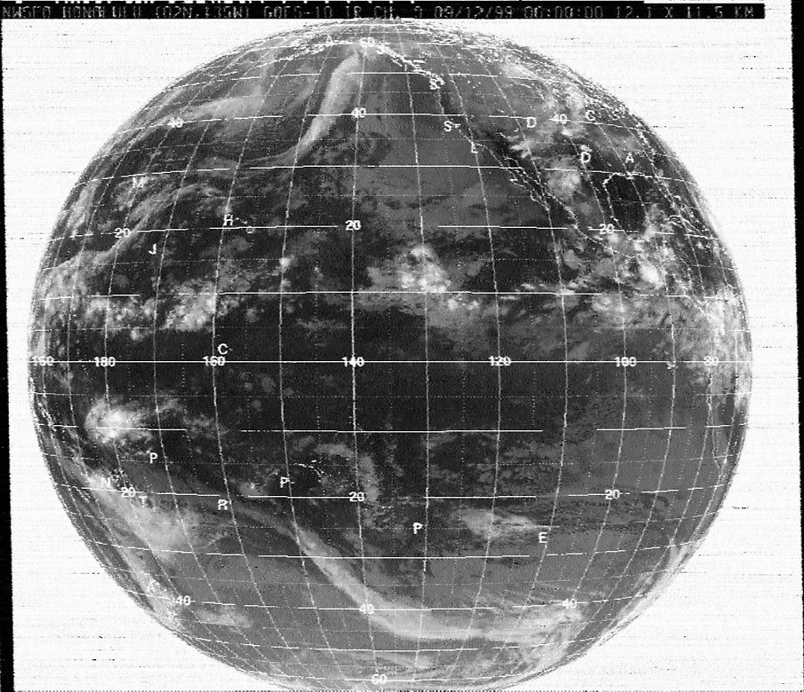
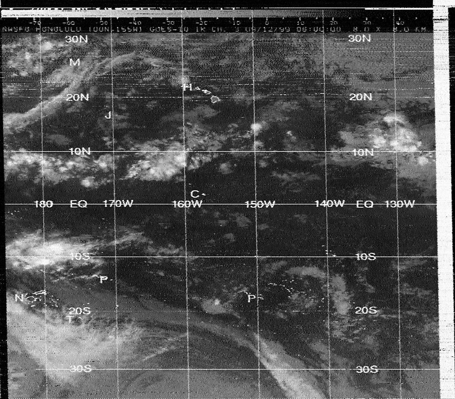
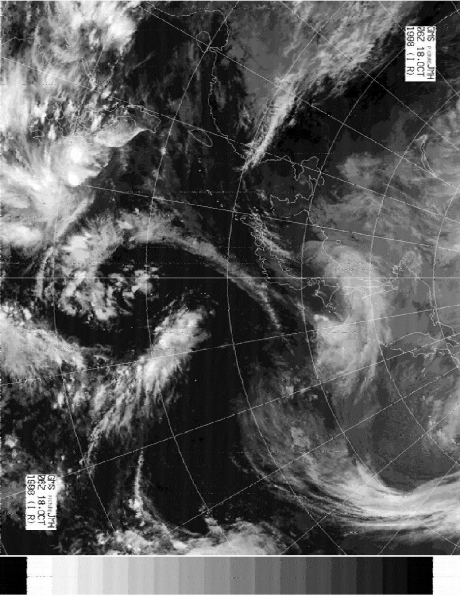
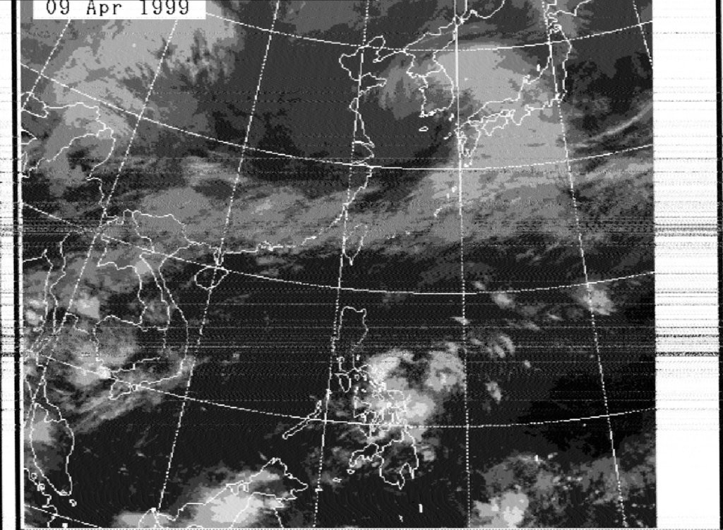
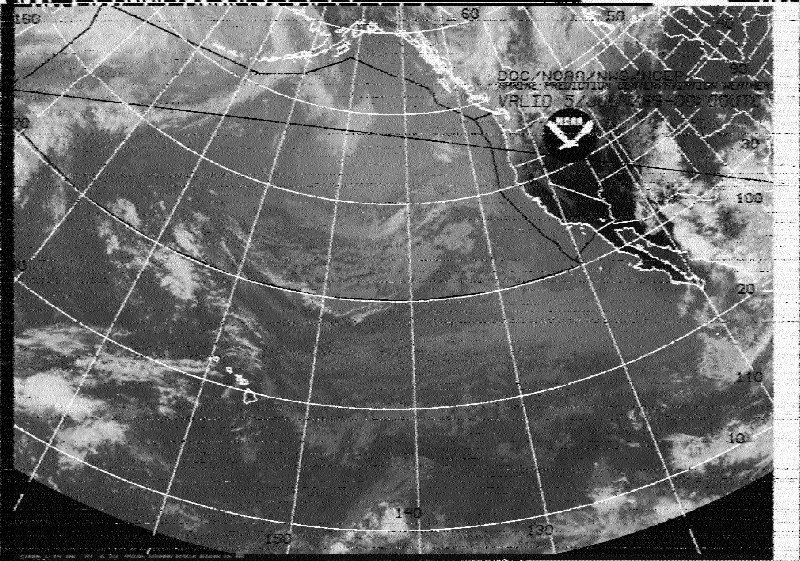
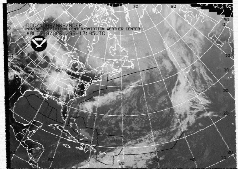
Take a look at the Satellite pictures received on shortwave at my location Hannover, Germany.
Honolulu Meteo (GOES-10 IR CH0 central Pacific area) and (GOES-10 IR CH3 Hawaii area)
Tokyo Meteo (GMS IR west Pacific area)
Taipei Meteo (GMS IR Taiwan area)
USCG San Francisco (GOES-10 IR east Pacific area )
USCG Boston (GOES IR NW Atlantic / USA)
USCG New Orleans GOES IR Gulf of Mexico)
Delhi Meteo (INSAT) not available
Now available: WXSat Version 2.57 (rev.7) with Spanish and English help files, for Download see below
Many thanks to the Author of WXSat, Christian Bock making such an interesting and useful program for people who are interested in Weatherfax.
Christian Bock the author of WXSat send me the new Version V2.5 rev.7 released Sep 1999
WXSat is FREE for school and private/amateur use.
WXSat for Windows 3.1/95/NT, decodes the signals in the APT format from NOAA, Meteor, Okean, Resurs, Meteosat and GOES Satellites (AM) with a Soundcard.
WXSat can decode also FM-Fax for decoding facsimile-signals transmitting via shortwave.
WXSat works with the soundcard input so there is no external sampling hardware required. A cable between the receiver and the soundcard input is enough. The program has also a good English documentation.
Note on the use of WXSat 2.57
Problem: After an automatic recording session with the "No Output File" option the bitmap functions "Load" and "Save as" cannot be selected under some operating systems.
Work-around: A new automatic recording "Start on ..." with the "Save Bitmap" option should be initiated and immediately stopped again.
Care must be taken that during this time no input signal transfers the software from the stand-by to the active state because otherwise the
displayed bitmap is discarded from memory. Now the bitmap functions should work normally.
For downloading WXSat V2.57 (833K) Spanish/English help file Version (AM and FM) click here. Spanish translation by Pauli Nunez, EA3BLQ. September 18 1999
For downloading WXSat V2.57 (660K) Spanish help file Version (AM and FM) click here. Spanish translation by Pauli Nunez, EA3BLQ. September 18 1999
For downloading WXSat V2.57 (614K) English Version (AM and FM) click here. September 18 1999
Spanish documentation File for WXSat Version 2.4 translated by Pauli Nunez, EA3BLQ. It's here: WXSAT_ES.DOC
Oded Regev 4Z5BS from Israel has written a small program called TRACKER v1.0 that allows the creation of maps that can be combined with images taken
from NOAA satellites.
I have test it successfully with NOAA images received with WXSAT and JVComm. With it you can see country borders and sea/surface boundaries.
The program is quite small but it comes with the world map so it is about 3.4 Mb in total.
Here is a example from a NOAA 14 picture decoded with WXSAT and added the country borders from the TRACKER program.
For more examples take a look also on Peter Tanner´s Weather Pages
If possible, Oded Regev would prefer that before adding the program to my HF-FAX pages, he asked to find several people that can help him testing the program to see that it actually works before releasing it.
If you are interested to test the tracker program, please send a note (I am on Vacation next 3 Weeks) direct to the author: Oded Regev 4Z5BS
After several replies from test users, Oded send me a corrected version v1.1. It should work better now. There is still a known bug regarding fast Pentium
computers.
The ORBIT program will not run on fast computers (somewhere around 300Mhz and above). The only way to fix it is running a TSR program that slows the computer in DOS mode.
You will probably find such TSR programs here . In the next version Oded will try to add it to the release.
v1.1: Fixed bug in TRACKER.EXE with longitudes in the range 100E-360E (=100E-0E)
Test users should download the upgrade from v1.0 to v1.1 here and copy the new files to the TRACKER directory
Julian Moss wrote a application called SatMon. With this utillity you can recording audio signals from weather satellites as WAV files to decode with WXSAT or other programs.
David J Taylor wrote a decode program called SATDEMOD
With this program you can demodulate METEOR 3-5 signals from pre-recorded .WAV files. This program produce higher resolution images without the bent verticals resulting from WXSAT.
Les Hamilton wrote a program called PALETTE to optimised the colors from images decoded with WXSAT.
PALETTE is a Windows 3.x/9.x compliant program wich operates on luminance bands within a BMP image produced using WXSAT in conjunction with an image processing program such as Paintshop Pro etc.
Radek Vaclavik OK2XDX has developed a very simple downconverter for Meteosat. He has published it on the QSL Net from here you can download also some Meteosat WAV files.
Radek Vaclavik OK2XDX has developed a very small receiver for Meteosat. He has published it on the QSL Net
A new free Windows satellite tracker programm called SatScape is now available.
Satscape a specialised program that predicts where satellites are at the moment. You have also a World view, Horizon views, tabular list and a keppler update via your Internet connection.
The PA0ROJ Quadrifilar ROJ-antenne
JVComm Beta 0.9 from Eberhard Backeshoff, DK8JV now available, this new 0.97 release supports also transmission/reception via sound cards.
At least a 16 bit sound card is required, and the the computer should be a Pentium 90 or better. You can download JVComm32 as a unregistered demo version from Eberhard Backeshoff´s Home Pages
Central Europe was cloud-free and we had summery weather. I have uploaded two NOAA 14 Images received 09 & 10 May 1998.
The APT Satellite pictures are decoded with WXSat and with a good resolution (>400K), so you can print them also as a color picture on Glossy paper/film.
For download go to Weekly Picture.
On May 05 1998 I have received the first APT Image from Meteosat 7, it was disseminated via Meteosat 6 channel 1 at 0823 UTC.
I have decoded this Image with JVComm32 and EasyDSP
Alberto Casappa (Italy), has written two usefull applications for receiving Meteosat pictures via WXSat.
The applications are written in Visual Basic.
Meteosat scheduler with a little bit Hardware (only five parts) let you select between IR, VIS or ALL pictures.
Scheduler is a real time scheduler for Meteosat.
For downloading the Meteosat Scheduler visit Alberto Casappa´s new Home Page
A new satellite wefax image decoding software called SATFAX from John Lee Wilson W4UVV is now available to the public.
It originally was written to accommodate the image noise dot saturation problem thet occurs when the disered 40 kHz bandwidth.
SATFAX was designed for the occasional wefax monitor who wishes to use an ICOM R700, R7100, or AOR 3000A (also other receiver/scanner that receive either 1691 MHz or the 137 MHz range) and soundcard
in his computer with wefax software to receive polar orbiting and geostationary satellites.
What makes it so special is that in processing the wefax signal, the software compensates for the narrower bandwidth of receivers that typically have a 20 kHz bandwidth for wefax reception.
I have uploaded 2 WAV files (MET35.WAV and METEO_SAT.WAV) for use with the WXSat program. You will find them here
Other files will coming soon. With thanks to Scott Gennari who spent me the space on the ftp server.
WAV Soundfiles (Meteor and NOAA)
Audio filter for WXSat from Salvador Esteban EB3NC
Preamp for 137 MHz
 Okean 4
(called also Okean 1-7) provide radar, microwave and optical images for sea navigation and ice situation in the Arctic, Antarctic and northern seas. The received APT images on 137.4 Mhz have mostly a visible light image, a low resolution microwave scanner image and a radar image.
Okean 4
Okean 4
(called also Okean 1-7) provide radar, microwave and optical images for sea navigation and ice situation in the Arctic, Antarctic and northern seas. The received APT images on 137.4 Mhz have mostly a visible light image, a low resolution microwave scanner image and a radar image.
Here is one of the few scheduled Okean pictures (208K) from week 4-11 May, received at May 7 1997 0429-0436 UTC, from this passes I could only receive Okean from 0432-0436 UTC, so I missed the first 3 minutes.
Equipment:
Weather Satellite Receiver: NIMBUS 137 and Wraase MR-9202 *.
Antenna: RF Sytems WSA-137/WSP-137 active/passive antenna.
Software: JVComm32 and WXSat.
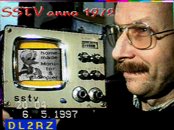
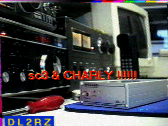
* = Volker Wraase DL2RZ is one of the SSTV pioneers (Wraase modes), here are two SSTV pictures wich I received 08 May on 3730 kHz, Mode Martin 1:
SSTV at 1972 from Volker Wraase
SC3 and CHARLY one of the best SSTV equipment from Volker Wraase
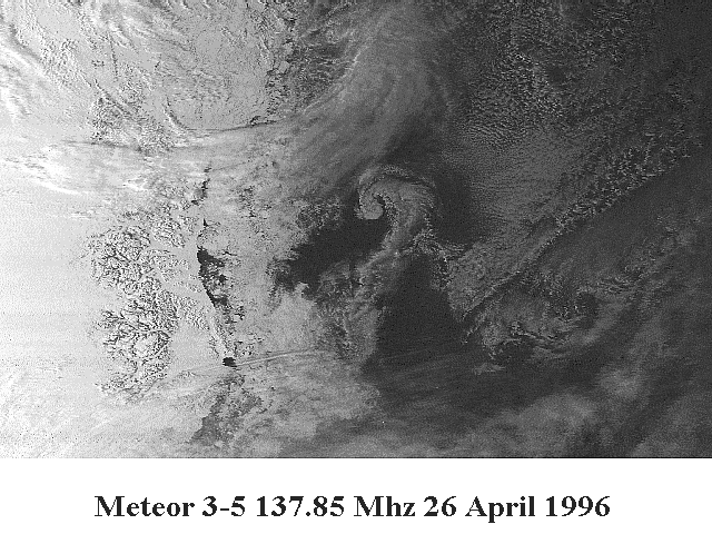
 Meteor 3-05
 one of the "long live" Russian weather satellites transmitting daytime visible APT images, the infra-red sensors ceased activity end 1993.
Meteor 3-05
Meteor 3-05 one of the "long live" Russian weather satellites transmitting daytime visible APT images, the infra-red sensors ceased activity end 1993.
Meteor 3-05 orbit 1200 km above the earth, so it has a greater range than the NOAA satellites (800 km). Some passes are up to 20 minutes.
The images shows the cloud, snow and ice cover excellent, but land details are very poor.
Here is a small detail from one of the 26 April passes from the mid Atlantic to the North pole, it shows the east cost of Greenland.
Meteor 3-5 East coast Greenland (105K). This image was decoded with WXSat V2.3
Links to other WEFAX Enthusiasts
de kunstmaan groep from Joop Meijer
Otso Laakso, Finland with a image archive which include all his colorised NOAA pictures since 1997.
The KB8UKP Amateur Radio and WXSAT Page
University of Cordoba, Argentina NOAA and Meteor images of South America
Michael Pedersen (Denmark)
Hartmut Schaksmeier (Germany)
Mike Dunn´s Web Page (Tasmania)
Laura Halliday´s VA3LDH Web Page
Jim K2TL using WXSat .
Peter Tanner´s Web Page
Archived Pictures from Noel
Mika Iisakkila Weather Satellite page from Finland.
Steve Blackmore Weather Satellite page.
Ian Busby Weather Satellite Image Homepage, using WXSat.
Kevin´s Weather Page
Download a NOAA 14 image from Milan Konecny VE3NZK using WXSat.
Download a image from Salvador Esteban Munoz EB3NC, Barcelona Spain using WXSat .
German Weather Satellite Page from Markus Brylka is back, using WXSat.
Les Hamilton Weather Satellite Image Pages, using WXSat .
If you have any questions or suggestions about WXSAT please give me a note, I will forwarded them to Christian Bock.

Back to the Homepage